|
The Trail of Death marker for Pyatt’s Point is in present-day Monticello. The historical marker is at the north end of the City Cemetery on the west side of Monticello. To find the marker, turn right (north) at the intersection of 1550N and Market Street. Follow Market Street to Livingston. Turn left (west) onto Livingston for a few blocks and go to N. Park Street. Proceed on N. Park for 1 block to Railroad Street, which passes under railroad overpass. Follow Railroad Street for about 1 block to cemetery, which will be on the left. The Trail of Death marker for this site is beside the street, just up a small grassy slope. 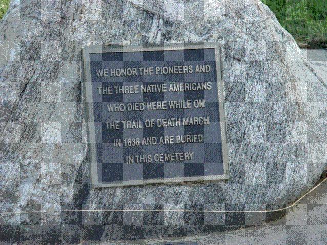
Monticello, Illinois - City Cemetery. GPS N-4001632 W-8834612. Boulder with metal plaque in front of Monticello City Cemetery on Railroad Street. Erected 1998 by Boy Scout David Moody for Eagle award. (Photo by Larry Prichard, Lynn, Indiana, on Trail of Death Commemorative Caravan, 2003.) 
Monticello, Illinois - City Cemetery. GPS N-4001632 W-8834612. Pictured with Boy Scout David Moody at dedication ceremony during Trail of Death Commemorative Caravan in 1998. Note the small plaque below the boulder; it has the Boy Scout’s name, date and troop. (Photo by Bill Willard, 1998) The other Trail of Death marker is on Bridge Street, which is a very busy street so it is best to park at the cemetery and walk across the railroad track and around to Bridge Street. The Trail of Death marker is on the south side of Bridge Street next to a steel fence. |
| < Previous | Home | Next > |