|
After crossing the state line into Illinois, turn north (right) on CR 1100W heading back toward State Line. At the first road on the left, turn west (left) on County Road 29 (Poland Road). Take that west, under old railroad to the Vermilion County Airport (on your right). Turn South (left) on 1800E (Bowman Road) to 2100N (next right) which is also Liberty Lane. Turn west (right) and go over the tracks. The Trail of Death camp site was along Stony Creek to the south where Turtle Creek Golf Course is. Then continue west on Liberty Lane. At the stop light (McDonald’s and Steak ’n Shake) turn south (left) on North Vermilion. Stay on this through downtown Danville. At Redden Square (courthouse on left) turn west (right) on highway US136 also known as Main Street. Follow US136 as it becomes US150, continue on US150 to Ellsworth Park on the Vermilion River. To enter the park, cross the river bridge and turn north (right) onto Avenue A. In the park, go 2 blocks and turn southeast (right) on Ellsworth Drive. The Trail of Death marker is next to the concrete walk just before you get on the bridge. 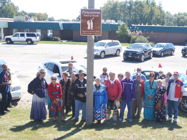
Turtle Run Golf Course, Danville, Illinois. This historic highway sign was dedicated Sept. 24, 2013, by Trail of Death Commemorative Caravan at Turtle Run Golf Course on Liberty Lane. The Trail of Death camp site was along Stony Creek to the south of this golf course. Caravan members gather by the new sign. From left: Sharon Hoogstraten & mother Jo, Julie & mother Susan Estall, Rich Meyer, Bill & Shirley Willard by the post, Cathryn Wamego, George Godfrey, Carmelita Wamego Skeeter & grandson Chris Osborn, Bob Pearl in front of Dan Noyes - video maker, Jeannie Wamego Van Veen, Sister Virginia Pearl, Lois & Ralph Bazhaw. Sunday 16th Sept. [Traveled 15 miles from just east of Indiana state line to Danville, Illinois.] At 8 o’clock we were loaded and in our saddles. Left 7 persons sick in camp, among them a woman who was about to be confined [give birth]. A few minutes travel brought us to the Grand Prairie. Crossed state line at 11:30. The heat along with the dust is daily rendering our marches more distressing. The horses are jaded, the Indians sickly and many of the persons engaged in the emigration more or less sick. The whole country through which we pass appears to be afflicted - every town, village and hamlet has its invalids. We find provisions and forage, the further we advance, demanding most enormous prices. Camped at 3 p.m. near Danville, population 800 to a thousand, and 4 people died in town. [Father Petit arrived, got chiefs out of jail wagon, baptized dying babies.] 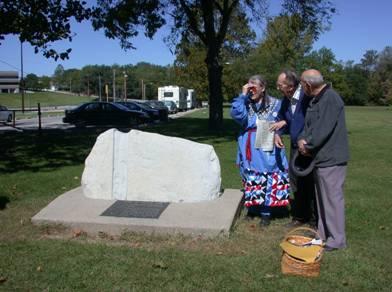
Danville, Illinois - Ellsworth Park. GPS N-4007511 W-8738403. Located in Ellsworth Park by bridge over the Vermilion River on west side of Danville. The boulder was donated by Paul Quick, a Cherokee, and member of Society of Indian Lore (S.O.I.L.) He made the cut to make it look like an arrowhead. Erected in 1993. Pictured are Shirley Willard, with Hugo Zeiter, and Hubert Powell, SOIL members. (Photo by Larry Prichard, 2003 Trail of Death Commemorative Caravan, 2003.) 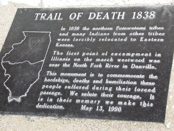
Danville, Illinois - Ellsworth Park. GPS N-4007511 W-8738403. Close up of Trail of Death marker. (Photo by Larry Prichard, 2003.) Leave Ellsworth Park and go back east on US150. Cross over the Vermilion River and turn south (right) on US150 (S Gilbert St.) & continue for 1 mile. Turn right (southwest) on Catlin Rd. (Tilton Rd.) & follow it 0.7 miles to E. 5th St. and turn west (right). Go 0.7 miles and the road angles southwest as Catlin-Indianola Rd. (CR7). Follow this road for 3.2 miles to Catlin. |
| < Previous | Home | Next > |