Plymouth on State Road 17There is another Trail of Death historical marker about 2 miles west of the Menominee Chapel monument. This sign is not on the actual route of the Trail of Death. It is located on the south side of 12th Road just before it crosses Indiana 17. 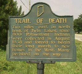
Plymouth, Indiana - Trail of Death metal sign. GPS N-4118162 W-8624433. Metal sign on post, erected by Marshall County Historical Society in 1949. Located on south side of 12th Road just before it crosses State Road 17. This was not on the route of the Trail of Death. (Picture from Culver - Union Township Public Library, Culver, Indiana.) To continue on the Trail of Death, turn around and go back east on 12th Road, turn south (right) on Olive Road, then turn east (left) on 13th Road and go to US 31, cross the highway and you are on Old 31, the Michigan Road. Follow it south through Argos. Potawatomi Trail of Death Regional Historic Trail highway signs mark the turns. The first night’s camp was at the Tippecanoe River and Old 31 (Michigan Road). |
| < Previous | Home | Next > |