|
To leave Jacksonville, head north on Mauvaisterre Street, which forms the east side of the Central Park Plaza. Turn west (left) on E. Douglas Avenue. Go 2 blocks and turn south (left) onto North Sandy Street. Go to West State Street, on west side of Central Park Plaza. Turn west (right) on W. State Street and go about 10 blocks to Duncan Park, which is on the north (right) side of West State Street. Turn north (right) into Duncan Place drive, which is marked Duncan Park. The next picture shows the evergreen tree planted by the Trail of Death Commemorative Caravan in 1988. The evergreen tree is on the south side of Duncan Place drive, a short distance south of the old Duncan Mansion. 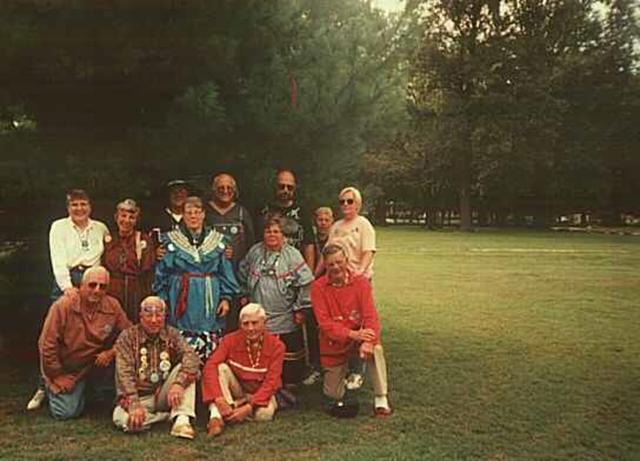
Jacksonville, Illinois - at evergreen tree in Duncan Park. GPS N-3944112 W-9014950. This evergreen tree was planted in 1988 by the members of the first Trail of Death Commemorative Caravan and Morgan County Historical Society. Pictured above in front row: Jim Pearl, Bob Pearl, Tom Hamilton, and George Wesselhoft. Middle row: Eileen Pearl, Sister Virginia Pearl, Shirley Willard, Susan Campbell. Back row: Bill Willard, Erick Campbell, Howard Kline, Dolores Grizzell, Barbara Kline. (Photo taken in 1998.) Leaving Duncan Place, turn south (left) on S. Webster Avenue and go for one block. Turn west (right) on W. College Ave. Go two blocks and just past Pitner Place, turn left (southwest) as W. College Ave. curves and then merges with Mound Avenue. Follow Mound Avenue to Old U.S. 36 and head west to Exeter. |
| < Previous | Home | Next > |