|
Perry In 1838 the Potawatomi were taken across the Illinois River on ferry boats at Naples. But today there is no road nor bridge crossing at that point, so you have to go to Meredosia, the nearest bridge, to get across the river. If you want to go to the site on the west side of the river, across from Naples, it is possible. But it is back a long lane on private property. The Trail of Death Commemorative Caravan drove back there in 1998, but found the site to be muddy, overgrown with weeds and trashed with beer cans. So it is not advisable to try it. After leaving Meredosia, follow 104 west. It will angle south and go through Chambersburg, where at the 4 way STOP, you turn south (left) on 107 and go 2 miles. When you come to 417th Street, leave highway 107 by turning west (right) - this becomes Federal Street, which enters Perry. At the first STOP sign, turn west (right) on Maine Street. Go one and a half blocks west to the town park on the north (right) side of Maine Street. This is next to the Post Office. The Trail of Death marker is near the sidewalk and water tower. Friday 5th Oct. [Traveled 12 miles from west bank of Illinois River to McKee’s Creek near Perry, Illinois.] Left encampment opposite Naples at 8 o’clock and reached at a little after 12 our present encampment at McKee’s Creek, 12 miles from the Illinois River. We were forced today to leave the road and travel a considerable distance to find water -- even such as it is - standing in ponds. - The streams are nearly all dry. Subsistence: beef & flour. Forage of a good character. 
Perry, Illinois - town park. GPS N-3946993 W-9044856. Located on west side of Illinois River at Mill Creek. (Photo by Larry Prichard, Lynn, Indiana, on Trail of Death Commemorative Caravan, 2003.) 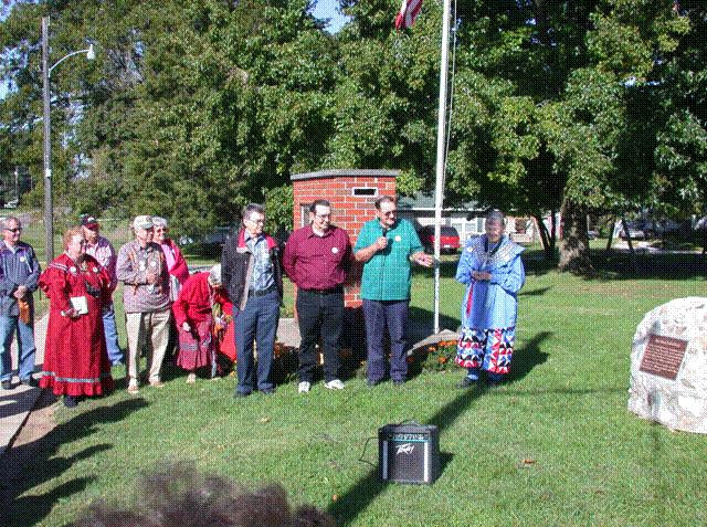
Perry, Illinois - town park. GPS N-3946993 W-9044856. Located in Perry town park. Erected by people of Perry community and Citizen Potawatomi Nation, 2003. Monument is at right - stonework was done by the Mountain brothers: Dean, Bill and Wayne, Perry, Illinois. Their great grandmother was a Potawatomi. Pictures above: Patrick Dockrey, Janet Pearl, unidentified man behind her, Bob Pearl, woman, Sister Virginia Pearl, the three Mountain brothers, Shirley Willard. (Photo by Larry Prichard, Lynn, Indiana, on Trail of Death Commemorative Caravan, 2003.) To leave Perry, go west on Maine Street which becomes Township 2650N in the country. This is also known as the Perry - Fishhook Road. (Years ago Fishhook got its name because it was the end of the stagecoach line and they turned around there.) Continue on this road even though it changes its name to Township 2810 N. Go 7 ½ miles to STOP sign at Fishhook and turn north (right) on Township 2518 E. Go ¼ mile to highway 104 and turn west (left) on 104. Go west 14 miles on 104 to Liberty. |
| < Previous | Home | Next > |